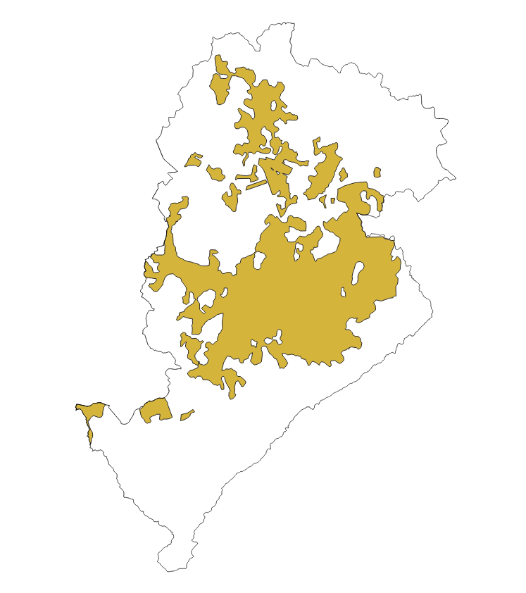
MANCHA URBANA 1950 BELO HORIZONTE
As áreas de expansão da mancha urbana refletem basicamente a ocupação no ano de 1950 em Belo Horizonte.
|
|
(2022) . MANCHA URBANA 1950 BELO HORIZONTE. http://geonetwork.pbh.gov.br/geonetwork/srv/api/records/6305f19e-2699-4114-9fd8-1296ed1661c9 |
- identificationInfo
- distributionInfo
- dataQualityInfo
- spatialRepresentationInfo
- referenceSystemInfo
- contentInfo
- portrayalCatalogueInfo
- metadata
- metadataConstraints
- metadataMaintenance
- applicationSchemaInfo
identificationInfo
Identificação de dados
Citação
- Data ( Publicação )
- 2022-11
- Data
- Finalidade
- Monitoramento e Urbanismo.
- Credito
- SUPLAN - Subsecretaria de Planejamento Urbano
- Status
- Concluído
Ponto de contacto
- Freqüência de atualização e manutenção
- Quando necessário
- ( Tema )
-
- evolucao , mancha , urbana , monitoramento , urbanismo
Restrições legais
- Restrições de acesso
- Licença
- Uso de restrições
- Licença
- Outras restrições
- Creative Commons Attribution (CC BY)
- Tipo de representação espacial
- Vector
- Languagem
- Portuguese
- Character set
- UTF8
- Categoria de tópico
-
- Planejamento Urbano e Uso Ocupação do solo
N
S
E
W
))
distributionInfo
Distribuição
- Forma de distribuição
-
- ( )
Distribuidor
- Recursos onLine
-
MANCHA_URBANA_1950
DICIONÁRIO DE DADOS - MANCHA_URBANA_1950
dataQualityInfo
referenceSystemInfo
- Identificador de sistema de referência
- SIRGAS 2000 - UTM ZONA 23 S
metadata
metadata
- Identificador do ficheiro
- 6305f19e-2699-4114-9fd8-1296ed1661c9 XML
- Languagem
- Portuguese
- Character set
- UTF8
- Date stamp
- 2022-07-28T18:58:36
- Nome padrão dos metadados
- ISO 19115:2003/19139
- Versão padrão dos metadados
- 1.0
Publicador
PRODABEL - SGS
-
GIGS - Gerência de Geoinformação
(Analista )
Belo Horizonte
GIGS - SGS
31230-000
Brasil